The entire Garden Route is a paradise for hiking but Nature’s Valley is particularly beautiful. From Nectar Cottage there are spectacular day walks, for example to Salt River Mouth, a route with impressive views via the coast to a remote bay and returning across the mountain. The famous Otter Trail starts at the imposing Storms River Mouth and ends with the spectacular view of the beach, lagoon and ocean of Nature’s Valley. Where permits are required these are usually issued at entrance.
The following are some of the day hikes and longer trails:
| Name | Info | Distance | Difficulty | permit needed |
|---|---|---|---|---|
| Otter Trail | see below | 48 km | Difficult | Yes |
| Tsitsikamma Hiking Trail
See map of trail here |
Starts in Nature’s Valley and ends 60-km further at Storms River. This 5 day, unidirectional trail takes hikers through the heart of the Tsitsikamma Mountains. Shorter variations (2,3,4 or 5 days) are possible as each overnight hut has its own unique access route with safe parking at the start. Contact the operator at +27 42 281 1712 | 61 km | Moderate to difficult | Yes |
| Tsitsikamma Guided Hikes | Various possible routes which all start at the Stormsriver Adventure Centre in the Storms River Village. All-weather activity, rain jackets supplied. Comfortable clothes should be worn and proper walking or hiking shoes/boots. Confirmation of bookings, final numbers and dietary requirements must be confirmed at least 24hrs in advance. Tours ccan be cancelled in the interest of safety.Storms river adventures |
average 3km | Relatively easy | No |
| Kalanderkloof Trail | Starts at Nature’s Valley. Gorgeous walk through the forest gorge with ancient Outeniqua Yellowwoods (also known as Kalanders) and rock pools, then up through the fijnbos with views over the lagoon. You can also extend this walk by branching off to Salt River mouth. See Salt River via Keurpad Trail Starts opposite De Vasselot camp site, a 2 km walk from Nectar Cottage |
4,8 km / 2,5 hrs |
Moderate | No |
| Groot River Trail | Starts at Nature’s Valley | 6 km / 2,5 hrs |
Moderate circular |
No |
| Forest Hall | Info: De Vasselot Camp Site | 15 km / 5 hrs |
Circular | |
| Salt River mouth route | Starts at Nature’s Valley | 9 km / 2,5 hrs |
– | |
| Salt River via Keurpad route | Starts at Nature’s Valley Info: De Vasselot Camp Site |
15 km / 6 hrs |
Difficult circular |
No |
| The Crags via Brak River | Starts at Nature’s Valley | 17,1 km / 7 hrs |
Route not circular | No |
| The Crags | Guided trail includes coastal fynbos, indigenous forests along Matjies River and Salt River, rugged coastline, well-established gravel and sand footpaths and easy climbs. Trail areas covered: Keurbooms, Forest Hall, Natures Valley, the Covie and Kurland trails, the historical Redford House, Bitou Valley Wetlands and Tsitsikamma Mountains. Contact Tel: +27 83 453 5331 | 4 days, guided | Moderate, reasonable fitness level required | |
| Kranshoek Hiking Trail | It starts at the Kranshoek picnic site. Take the Harkerville exit and follow the signs for about 7km till Kranshoek. You can leave your car at the picnic site. There is an optional shortcut up to the Kranshoek viewpoint and back to the picnic spot (about 4km) shortly after reaching the coast. | 9 km but reckon on at 5 hours for the longer route | The longer trail is difficult but beautiful | Fee at entrance |
| Varinghoek via Keurpad and back via the Brak River route | Starts at the top of Groot River pass on Plett side on R102 | 16 km / 6 hrs |
No | |
| Nature Valley Trails | Tel: +27 44 531 6700 | Differs | Varies | Yes |
| Harkerville Trail | Forestry Department Tel: +27 44 382 5466. You do not need to get a permit in advance to do this trail. | Can easily be done in one afternoon/day. If you prefer to extend it to 2 days forest, coast and fynbos and/or have a guided walk contact Tel: +27 (0)83 453 5331 | ||
| Outeniqua Trail | Forestry Department Tel: +27 44 382 5466 | 7 days indigenous forest and fynbos trail | ||
| Robberg Natures Reserve. | Highly recommended. Very diverse walk, there is a short trail and a longer one.
Tel: +27 44 533 2125 |
4 to 6 hours dependent on route | Moderate to difficult | Fee at entrance |
| Keurbooms Coastal ‘Explorer’ Eco-Hiking Adventures | Eco-Hiking Adventures offer guided hikes from Forest Hall to Nature’s Valley, from Keurbooms to Nature’s Valley and from Keurbooms to Forest Hall. Includes lunch.
Cell: +27 79 753 8968 E-mail: info@edu-eco.com Website: www.edu-eco.com |
half or full day | guided | n/a |
| Keurbooms-Matjies River walk | Tel: +27 44 533 3732 | 3 km | Moderate | No |
| Keurbooms Forestry Station | Tel: +27 44 533 2125 | Differs | Easy | Yes |
| Rugbos Trails | Tel: +27 (0)422-91 0393 | Differs | Varies | Self-issued |
| Stinkhoutkloof Trail | Tel: +27 422 91 0393 | 8,4 km | Difficult | Self-issued |
| Plaatbos Trails | Tel: +27 422 91 0393 | Differs | Moderate | Self-issued |
| Dolphin Trail: luxury hiking trail | Tel: +27 42 280 3588 Dolphin Trail |
20 km | Easy to moderate |
Yes |
| Storms River Mouth Trails | Tel: +27 422 81 1607 | Differs | Varies | Pay at entrance |
| The Mouth Trail | Starts at Sandy Bay, Storms River Mouth Rest Camp (next to the restaurant at Tsitsikamma Section) and takes one along a winding board walk through indigenous forest to the mouth of the Storm River, the famous suspension bridge, the Stormsriver Mouth Cave (Khoisan Heritage Site) and to the Spirit of Tsitsikamma boat jetty. For the more energetic, the trail continues after the bridge and leads to the lookout point on the plateau. |
2km – 1 hour |
||
|
Lourie Trail |
Starts at Storms River Mouth Rest Camp (Tsitsikamma Section) and emerges onto the plateau at the Agulhas lookout point, after a brief uphill climb. The trail then passes through a short section of fynbos, before continuing through the spectacular coastal forest. | 1km – 1 hour | easy | e |
|
Blue Duiker Trail |
Starts at Storms River Mouth Rest Camp (Tsitsikamma Section) and is a slightly longer version of the Lourie Trail and will take you into the heart of the forest with the giant Outeniqua Yellowoods. The trail ends at the beginning of the famous Otter Trail. | 3,7km – 2 hours | ||
|
Waterfall Trail |
The Waterfall Trail comprises the first 3km of the world-renowned Otter Trail with the spectacular waterfall at the end of the 3km stretch along the rugged coastline. We suggest that you make a day of it and take your bathing costume and a picnic meal. This trail will take you approximately 1½ hours to walk to the waterfall and 1½ hours back. | 6km – 3 hours | fairly strenuous, caution must be taken at high tides. | |
- See South African National Parks for hiking trails.
- To hike with others contact Garden Route Adventures or join a hiking club in the area.
- For more hikes along the Garden Route call the Plettenberg Bay tourist info line on Tel: +27 44 533 4065 or see: www.gardenroute.co.za/info/trails/hiking
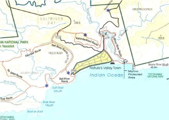
Hiking trails from Nature’s Valley
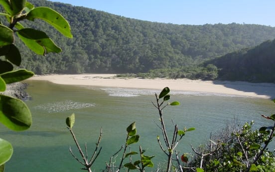
Salt river mouth
OTTER TRAIL
This five-day trail was the first official hiking trail to be opened in South Africa and ranks tops as one of South Africa’s most famous and spectacular hiking trails. The trail meanders along a unique and unspoilt coastal stretch of the garden route in the Tsitsikamma National Park coastal forest. It traverses 48 kilometres of mountains, forest, fynbos, beaches, crosses 11 rivers and estuaries, and is graded as one of the more difficult hikes. The trail supports a maximum of 12 persons one way and hikers should be reasonably fit.
The trail takes 5 days and, as this hike is extremely popular, reservations for huts need to be made well in advance, preferably a year. There are 2 huts; each with 6 bunks and mattresses. All provisions such as sleeping bags, gas stoves, cooking utensils, etc, need to be taken with and carried on the trail. Barbecue facilities and chemical toilets are provided, as is firewood, which is left on the path and can be collected along the way. Water is either available at the huts or can be taken from the streams. No person should hike alone and care should be taken crossing rivers after heavy rains.
The trail starts at Storms River Mouth. Directions indicating the entrance to the Tsitsikamma National Park can be seen on the N2 near the Paul Sauer bridge over Storms River. The trail starts about 2 km west of the restaurant and car park at Storm’s River and is clearly marked with blue otter signs.
DAY 1(4,8 km, 2 to 3 hours). Passing a Khoisan cave you reach a pool and waterfall near the first night’s stop at the Ngubu huts. Great swimming.
DAY 2 (7,9 km, 4 to 6 hours). The second day starts with a steep climb up Olienboomkop onto a plateau of forest and fynbos with impressive Outeniqua Yellowwood and Stinkwood trees. Passing Skilderkrans with views of ocean and perhaps whales and dolphins, you cross the Kleinbos River towards Scott’s Hut where fresh-water swimming can be enjoyed at the Geelhoutbos River that flows into the sea. This is a demanding climb with ascents and descents but if you have the stamina consider a detour down to Bloubaai.
DAY 3 (7.7 km, 4 to 6 hours). The third day offers more undulating walks and is very scenic. The trail crosses two rivers, the Elandsbos and the Lottering, with wonderful swimming opportunities. Oakhurst hut can be reached either by swimming the Lottering or by hopping from boulder to boulder.
DAY 4 (13,8 km, 6 to 8 hours). Although this hike from Oakhurst to the next hut is the longest it is not too strenuous. Start early to enable you to take your time crossing the Bloukrans River at low tide. (It is advisable to check the tide table at the information centre before the start of the trail.) Should you miss the low tide or feel unsure about the crossing, you can travel inland along a clearly marked route and backtrack to Andre’s hut. At Andre’s hut you can replenish your fresh water supply on the banks of the Klip River.
DAY 5 (6,8 km, 2 to 3 hours) Approximately 100m after crossing the Klip River, ascend to a plateau of wooded areas and fynbos. Crossing the Helpmekaar River (fresh water supply) you reach the cliff top overlooking the pristine Nature’s Valley.
- For further information, maps and to check availability see South African National Parks
- Contact Information South African National Parks
PO Box 7400, Rogge Bay, Cape Town, 8012
Reservations can be made up to a year in advance: SANPARKS, PO Box 787, Pretoria, 0001
Telephone: +27 12 426 5111
Fax: +27 12 343 0905
E-mail: bridgetb@sanparks.org - See Ezine for an article on the Otter Trail
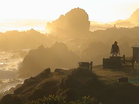
Storms river